Driving the Panorama Line: Niseko's Most Scenic Spring Road
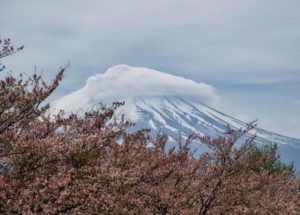
Every road in Hokkaido has a view worth slowing down for. But the Panorama Line -- officially Hokkaido Prefectural Route 66 -- is in a different category entirely. This winding mountain road connecting Niseko to Rankoshi unfolds one jaw-dropping panorama after another: the volcanic cone of Mount Yotei rising above green farmland, the peaks of the Niseko range still streaked with snow, and on clear days, the distant shimmer of the Sea of Japan. In late spring, when the road reopens after its long winter closure, driving the Panorama Line is one of the finest things you can do in Hokkaido.
There is no public bus or train along this route, so it is a scenic drive you can only do with your own car. This guide covers everything you need to plan it -- the route itself, what you will see, where to stop, and how to time your Hokkaido spring drive for the best conditions.
What is the Niseko Panorama Line?
The Panorama Line is a 30-kilometer stretch of Hokkaido Prefectural Route 66 -- known locally as Doudo 66-go, using Hokkaido’s own word for a prefectural road. It runs between the Niseko area and the town of Rankoshi to the south. The road climbs through the hills between Mount Niseko Annupuri (one of the Niseko ski peaks) and Mount Yotei, reaching elevations where the views open up in every direction -- hence the name.
The road is closed during winter due to heavy snowfall, typically from November through late April or early May. The exact reopening date varies each year depending on snow conditions, but it usually falls in the last week of April or the first week of May. You can check the current status through the Hokkaido Regional Development Bureau’s road information site before your trip.
From end to end, the drive takes about 40 minutes without stops. But nobody drives the Panorama Line without stopping. With photo breaks, short walks, and a coffee pause, plan for two to three hours to enjoy it properly.
Why Spring is the Best Time to Drive It
The Panorama Line is beautiful from opening day through autumn, but the first few weeks after the road reopens in spring are something special. The snow has only recently retreated from the lower elevations, and the contrast between the bright green of new growth and the white peaks above is at its most dramatic. Farmland on both sides of the road is coming back to life -- fresh-turned soil, young grass, and the first wildflowers appearing along the shoulders. If your timing is right, the tail end of Hokkaido’s late cherry blossom season may still be showing at lower elevations.
The light helps, too. Spring mornings in Hokkaido have a clarity that photographers chase -- the air is cool enough to stay sharp, and the low angle of the early sun picks out every ridge and valley on Mount Yotei. By June, the haze of warmer weather softens things. In the first weeks of May, everything is crisp.
Traffic is another factor. Summer brings tour buses and motorcycle groups to the Panorama Line, and weekends in July and August can feel busy. In late spring, you will share the road with very few other drivers. It feels like the whole landscape belongs to you. There is a reason locals consider this Niseko’s best off-season -- the scenery is stunning and the crowds have not arrived yet.
Highlights and Stops Along the Route
Whether you start from the Niseko side or the Rankoshi side, the Panorama Line has several natural stopping points. Here is a north-to-south sequence starting from Niseko.
Niseko View Plaza (Michi-no-Eki)
A michi-no-eki is a government-designated roadside rest station -- Japan has hundreds of them, each with restrooms, parking, and local products. Niseko View Plaza, at the northern end of the route, is a good place to start your scenic drive. It has a small shop selling local produce and snacks, and an open area with views of Mount Yotei. Pick up some local milk or a bag of Niseko potatoes for later -- the farm-fresh produce around Niseko is excellent. Parking is free and plentiful.
Mountain Viewpoints
As the road climbs south from Niseko, several pull-off areas offer panoramic views of both Mount Yotei to the east and the Niseko Annupuri range to the west. These are not formally designated viewpoints with signs and railings -- they are simply wide spots in the road where you can park safely and take in the scenery. The best pull-offs are in the middle section of the route, roughly 10 to 15 kilometers from the Niseko end, where the elevation is highest. Look for the gravel shoulders where other cars have clearly stopped before.
Konbu Onsen Turnoff
About halfway along the route, a side road branches toward Konbu Onsen -- an onsen is a Japanese hot spring bath, and Konbu is one of the quieter ones in the Niseko area. If you have time, the detour takes about 10 minutes each way and rewards you with a rustic soaking experience far from the crowds. Several small ryokan (traditional Japanese inns) here offer day-use bathing for around 500 to 800 yen. Hours vary by facility, so it is worth calling ahead or asking at your hotel before making the detour.
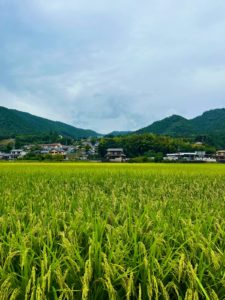
Rankoshi and the Southern End
The road descends into the Rankoshi plain on the south side, and the views shift from mountain drama to wide agricultural landscapes. Rankoshi is a small, quiet town known for its rice farming and clean rivers. If you arrive around lunchtime, the local restaurants serve simple, satisfying meals -- look for spots offering teishoku, a fixed-price set meal that typically includes rice, miso soup, and a main dish, made with locally grown ingredients. The Shiribetsu River runs through town and makes for a pleasant post-drive walk.
Planning Your Panorama Line Drive
When to Start
Morning light is best for the Panorama Line, especially if you are starting from the Niseko side. The sun rises behind Mount Yotei and lights up the western slopes of the Niseko range beautifully. Aim to leave Niseko by 7:00 or 8:00 AM for the softest light and the emptiest road. By midday, the light flattens and the views lose some of their depth.
A Half-Day Model Route
Start at Niseko View Plaza around 8:00 AM. Drive south on Route 66, stopping at the mountain viewpoints for photos. Detour to Konbu Onsen for a morning soak if you are feeling relaxed. Continue to Rankoshi for an early lunch, then loop back to Niseko via Route 5 along the valley floor -- a straight, easy road through farmland that passes through Kutchan before returning to the Niseko area. Total time: three to four hours including stops. Total driving distance for the loop: roughly 60 kilometers. Fill up on fuel in Niseko or Kutchan before you start, as there are no gas stations along the Panorama Line itself.
Checking Road and Weather Conditions
The Panorama Line is a mountain road, and spring weather in Hokkaido can change quickly. Check the forecast before you go, and be prepared for the temperature to drop noticeably at higher elevations -- even on a warm day in the valley, you may want a jacket at the summit. The road surface is well-maintained asphalt, but watch for damp patches in shaded areas during the first weeks after opening. For real-time road closure information, the Hokkaido Road Information site (available in English) lists all current closures and restrictions.
The Road is the Destination
The Panorama Line is not a shortcut to anywhere. It is a road you drive for the sake of driving it -- for the views, for the quiet, for that feeling of a landscape so big it makes the car feel small. Spring is when it is at its most alive, and this is a scenic drive in Niseko you can only do with your own wheels.
If you are staying in the Niseko area and looking for a morning or half-day outing, the Panorama Line is it. Land-N-Cruise Rent-A-Car is based in the Niseko area, and the team are locals who drive these roads themselves -- let them know you are planning the Panorama Line and they can recommend the right vehicle and share current road conditions. Spring in Hokkaido does not wait, so book your car early if you are visiting in May.